Glarus Süd
| Glarus Süd | ||||||||||
|---|---|---|---|---|---|---|---|---|---|---|
|
||||||||||
| Population | 9,820 (Dec 2010)[1] | |||||||||
| - Density | 23 /km2 (60 /sq mi) | |||||||||
| Area | 430.11 km2 (166.07 sq mi)[2] | |||||||||
| Elevation | 521 m (1,709 ft) | |||||||||
| Postal code | 8762 | |||||||||
| SFOS number | 1631 | |||||||||
| Localities | Betschwanden, Braunwald, Elm, Engi, Haslen, Linthal, Luchsingen, Matt, Mitlödi, Rüti, Schwanden, Schwändi, Sool. | |||||||||
| Surrounded by | Glarus, Muotathal (SZ), Andiast (GR), Flims (GR), Laax (GR), Mels (SG), Pfäfers (SG), Pigniu (GR), Ruschein (GR), Siat (GR)
Flums (SG), Quarten (SG), Breil/Brigels (GR), Disentis/Mustér (GR), Silenen (UR), Spiringen (UR), Sumvitg (GR), Trun (GR), Waltensburg/Vuorz (GR) |
|||||||||
| Website | www.glarus-sued.ch SFSO statistics |
|||||||||
|
Glarus Süd
|
||||||||||
|
Map of Glarus Süd
|
||||||||||
Glarus Süd is one of three municipalities of the canton of Glarus, Switzerland (the others being Glarus and Glarus Nord).
Effective from 1 January 2011, Glarus Süd incorporates the former municipalities of Betschwanden, Braunwald, Elm, Engi, Haslen, Linthal, Luchsingen, Matt, Mitlödi, Rüti, Schwanden, Schwändi and Sool.[3]
With an area of 426 km2 (164 sq mi), Glarus Süd is the largest Swiss municipality, followed by the formerly largest municipality of Bagnes, Valais (282 km2 (109 sq mi)).
The municipality comprises the upper Linth valley, and the entire Sernf valley. It encompasses altitutes from 504 m (1,654 ft) at Mitlödi to the summit of Tödi at 3,614 m (11,857 ft). Notable reservoir lakes are Limmernsee at 1,857 m (6,093 ft) and Garichtisee at 1,648 m (5,407 ft).
Contents |
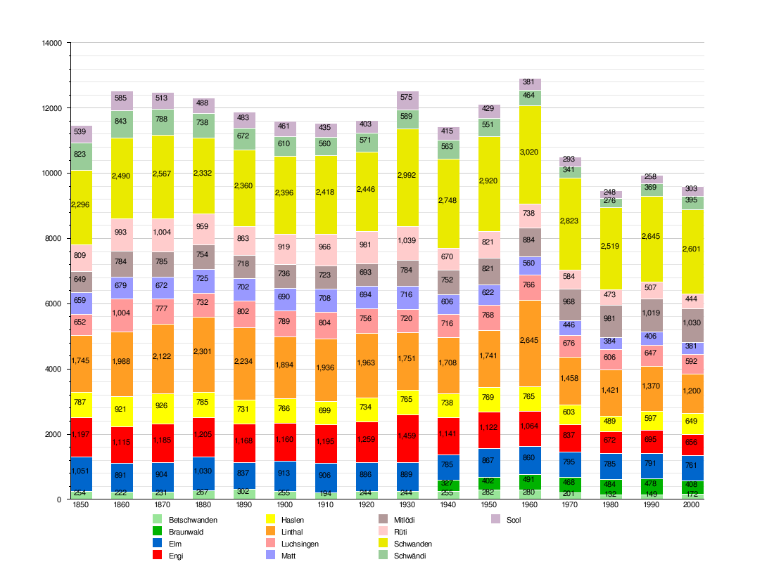
Historic Population
The historical population is given in the following chart:[4] 
See also
References
- ^ Swiss Federal Statistics Office – STAT-TAB Ständige und Nichtständige Wohnbevölkerung nach Region, Geschlecht, Nationalität und Alter (German) accessed 10 December 2011
- ^ Arealstatistik Standard - Gemeindedaten nach 4 Hauptbereichen
- ^ Amtliches Gemeindeverzeichnis der Schweiz published by the Swiss Federal Statistical Office (German) accessed 18 February 2011
- ^ Federal Statistical Office STAT-TAB Bevölkerungsentwicklung nach Region, 1850-2000 (German) accessed 29 January 2011
External links
|
|||||||||||||